Have a question for the project team or a suggestion relating to the development plan?
Tell Your Friends About This Project
Yoshihara Trail - looking north
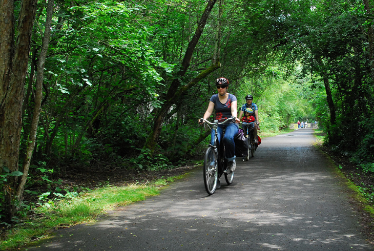
Yoshihara Trail - looking south with cyclist
Springville Road crossing - looking south
Mid-project - looking south
Westside/Rock Creek Trail connection - looking north
Trail Officially Named
THPRD aspires to name trails after the people, cultures, and natural features of our region. Names should welcome all people and inspire us. After extensive public outreach, THPRD’s board of directors approved naming this trail Yoshihara Trail (yo-she-ha-ra) at their regular meeting on January 13th, 2021.
The Yoshihara family established the Yoshihara Berry Farm in Beaverton. During WWII, the Japanese American family was forced to leave their home and taken to a concentration camp in Idaho. Family members have since played critical roles in their communities, and continued growing their families. The name honors Japanese American heritage in this area.
Thank you to all our community partners and members who shared input on these new trail names!
Project Overview
Yoshihara Trail (formerly referred to as Bethany Creek Trail #2) Segment 3 is a new half mile community trail segment located in the Bethany area of Washington County and rural western Multnomah County. It extends from THPRD’s Rock Creek and Westside Regional Trails north to NW Springville Road along the east edge of Kaiser Woods Natural Area and Kaiser Woods Park. The project includes a lighted pedestrian crossing at NW Springville Road providing connectivity to trails and neighborhoods in north Bethany. The trail alignment runs almost entirely within a Bonneville Power Administration (BPA) right-of-way (ROW), and the project spans multiple jurisdictions including Washington and Multnomah counties.
The project kicked off in January 2018. THPRD's design consultants began surveying and mapping of the project area for site analysis in March 2018. Public outreach and master planning efforts also began in March 2018 and continued into fall 2018.
THPRD held a neighborhood meeting on June 26th, 2018 to provide an overview of the project and receive public input on the conceptual master plan. Public input was also received after the meeting via email and online through July 10th, 2018. THPRD held a second neighborhood meeting on September 10th, 2018 at the CPO 7 regular monthly meeting in Bethany, where staff and the design consultant presented a project update and the preferred master plan for public input. Public input was also received after the meeting via email and online through September 17th, 2018.
Materials from the public meetings can be viewed in the Documents & Media section of this web page. The public input received during the outreach process has helped to guide district staff and the design consultant in the project planning and refinement of the preferred master plan.
The THPRD board of directors approved the Preferred Master Plan at their regular meeting on October 16, 2018. The Approved Master Plan can be viewed in the Documents & Media section of this web page, labelled "Approved Master Plan 10/16/2018".
The project received land use approvals and site development permits from permitting authorities in early 2020 and was publicly bid in March/April 2020. THPRD's board of directors awarded the construction contract at their regular meeting on May 12, 2020 to Lyda Excavating, Inc. and construction began in early June 2020.
Update
Construction of this trail segment was completed in December 2020 and the new trail is now open for public use! Trail improvements include a half mile of 10-foot wide paved community trail and a lighted pedestrian street crossing. There are multiple THPRD properties and parks within a half mile radius of the project, and this new community trail segment provides connectivity to adjacent trails, parks, schools and neighborhoods within the Bethany area. Please direct project-related comments or questions by email or through the online comment form.
***Please note: All plans, dates and information are subject to change***
(Content updated 6-8-2021)
Description & Map
Timeline
News
Description
Yoshihara Trail (formerly referred to as Bethany Creek Trail #2) Segment 3 is a new half mile community trail segment located in the Bethany area of Washington County and rural western Multnomah County. It extends from THPRD’s Rock Creek and Westside Regional Trails north to NW Springville Road along the east edge of Kaiser Woods Natural Area and Kaiser Woods Park. The project includes a lighted pedestrian crossing at NW Springville Road.
Trail Connections: Westside Trail, Rock Creek Trail, Kaiser Woods Park & Natural Area, North Bethany (Bethany Creek Falls)
Timeline
Project Duration: approx. 37-40 months
Project Start: January 2018
Public Outreach: Standard (approx. March – October 2018)
Board MP Approval: October 2018
Proposed Construction Schedule: anticipated June – Sept 2020 (4 months)