
- Recreation Centers
- Cedar Hills
- Conestoga
- Elsie Stuhr Center (55+)
- Garden Home
- Sports Facilities
-
Babette Horenstein
Tennis Center -
Tualatin Hills
Athletic Center - HMT Complex
- PCC-Rock Creek
- Sunset Park
- Field Status Website
- Pools
-
Tualatin Hills
Aquatic Center - Aloha
- Beaverton
- Conestoga
- Harman
- Sunset
- Raleigh summer only
- Somerset West summer only
- Nature Facilities
-
Tualatin Hills
Nature Center -
Cooper Mountain
Nature House
- Historic Facilities
- Fanno Farmhouse
- Jenkins Estate
-
John Quincy Adams
Young House - Service
-
Fanno Creek
Service Center - Administration
- Schlottmann House
Parks & Trails
- Natural Areas
-
Cooper Mountain
Nature Park - Tualatin Hills Nature Park
- Nature Play Areas
- Other Natural Areas
- Projects
- Future Park at NW Heckman
& 159th Ave - Future Westside Trail Bridge
over Highway 26 - Downtown Beaverton Parks Plan
- >> More Projects
- How was your park or trail experience?
- Let us know.
- Report a Concern
- Park Watch Report
Activities
Events
- Special Events
- Event Calendar
- Big Truck Day
- Centro de Bienvenida
- Summer Concerts
- Summer Neighborhood Events
- Volunteer Opportunities
- Welcoming Week
- Upcoming Events
- Public Meetings
Connect
 The Tualatin Hills Park & Recreation District is nearing completion on a multifaceted Waterhouse Trail expansion project that will make more than two miles of new pathway available to the public.
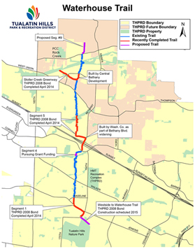 Stoller Creek Greenway, the “West Spur” trail (connects Waterhouse Trail to Rock Creek Trail). This connection between the Waterhouse and Rock Creek trails is a community trail that follows a tributary stream to Rock Creek. It includes a boardwalk along the stream within the link between Laidlaw Road and the Rock Creek Trail. This segment is 0.55 miles long.
 A .73-mile connection from Springville Road to the future North Bethany trail system, the northernmost section of the Waterhouse Trail. It is anticipated that this segment will be built as development occurs in North Bethany.